Bathymetry
A detailed knowledge of the morphology of the continental margin and the incoming oceanic plate is essential for understanding subduction processes. Major earthquakes occur at subduction zones, which can produce tsunamis. Knowledge of the ocean floor topography is a necessary precondition for detailed modelling of the propagation of tsunami waves. In addition, bathymetry in the shallow-water zone of the coastal region of western Indonesia is used for calculating wave heights of the approaching tsunami for coastal areas. The relevant coastal strips can then be evacuated in a targeted manner in case of an emergency. Detailed mapping of the ocean floor is therefore necessary in order to obtain a precise picture of the ocean floor morphology.
Two main systems are available to map the ocean floor within the context of GITEWS. The Kongsberg-Maritime EM 120 system, installed on the German RV SONNE, is a deep-water multibeam echo sounder. This makes it possible to provide accurate bathymetric mapping up to full ocean depth. The Seabeam 1050 D shallow- and medium-depth water multibeam echo sounder, was installed on the Indonesian RV Baruna Jaya IV. This can be used to map the near-coast regions with water depths from 0 – 3000m along the continental margin. Both systems are comprised of two linear transducers with various units for transmitting and receiving. The nominal sonar frequency is 12 kHz for the EM 120 with an angular coverage sector of up to 150° and 191 beams per ping. The Seabeam 1050 D transmits 50 kHz signals for medium depth and 180 kHz for shallow water. The maximum angular coverage is also 150°, however with 126 beams per ping. The water depth is calculated using the two-way travel time and the beam angle of each individual beam. The refraction due to sound speed variations in the water column must be taken into account. The data acquisition takes place at a constant ship's speed of 10 knots. This ensures good data quality and gap-free coverage of the floor along a profile. Reliable calculations of the depth values are achieved with regular pitch and roll calibrations, as well as waterborne sound profiles. The processing of the data is also important, in order to remove artefacts and outliers and thus improve the data quality. On the basis of this cleaned data, bathymetric maps can be produced with a higher resolution. The horizontal data resolution is better at 100 m in deep water and better than 3 m in shallow water. Vertically, the resolution is better than 0.5% of the respective water depth.
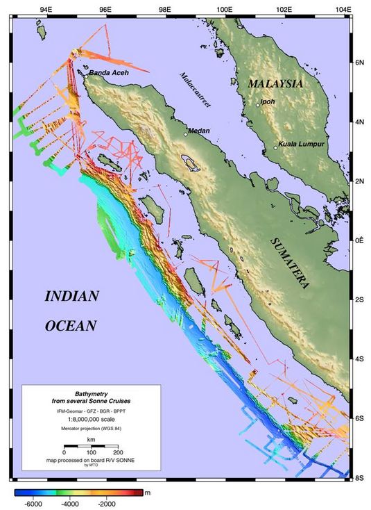
The coordinated data recording along the continental margin of western Indonesia makes it possible to cover larger areas. The data collected by RV SONNE are shown in the figure. With future journeys, e.g. in order to position additional GPS buoys and Ocean Floor Units, gaps that still exist will be closed.
 |