Source modelling
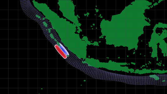
The main task of source monitoring is to quickly convert seismic and geodetic observations of starting conditions for a tsunami for modelling the tsunami propagation. Primary seismic parameters of a quake in the ocean near the coast of Indonesia - magnitude and epicentre - are already known after 2-4 minutes in the warning centre. However, a realistic source model needs many parameters than the seismology can deliver in real-time. Therefore, source modelling integrates the existing geological and geophysical know-how about the geometry and structures of the possible fracture zone, e.g. the deep-sea Sunda Trench (see figure). This trench extends from the Indonesian Islands in the Indian Ocean, from Sumatra to Java and Bali, right up to the small Sunda Islands). First of all, a relevant ocean floor deflection is calculated for each individual calculation point (see grid in Figure 1) using an analytical-numerical process (so-called "Green's Function"). If a quake is localised in an emergency and its magnitude is evaluated, the source modelling software models the quake for the calculation point and derives the resulting initial tsunami wave by added up the contribution of the individual calculation points.
To ensure a source determination in real-time even more quickly and accurately, scientists of GFZ Potsdam have proposed the innovative 'GPS Shield for the Tsunami Early Warning Near Field' and implemented it in the GITEWS project for the first time. On the basis of co-seismic displacements that the surrounding GPS stations experience due to the quake, within only a few minutes, additional statements can be made about the spatial course of the quake - the information that is of critical importance for the further modelling of the tsunami propagation.
