A tsunami (Jap. 津 波, harbour wave) is a water wave that is generated by sudden displacement of huge volumes of water. In 90% of cases, this displacement is caused by the deformation of the ocean floor during a major earthquake. However, landslides, volcanic eruptions, and theoretically also meteorite impacts, are possible causes. However, all of these mechanisms have in common, that they can generate seismic waves that travel through the earth with a velocity of several kilometres per second. In contrast, tsunami waves only reach velocities of several 100 kilometres per hour. After an earthquake at the Sunda Trench - off the coast of Indonesia - seismic waves arrive at the coast in approximately 30-40 seconds. However, the running time of the tsunami is a minimum of 20-30 minutes. Therefore, a dense network of seismological stations, that register the seismic signal are an important component of the GITEWS (German Indonesian Tsunami Early Warning System).
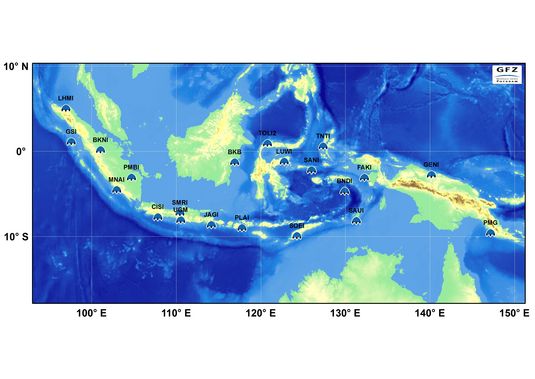
The task of the seismological component is the near real-time automatic detection of tsunamigenic earthquakes, as well as the determination of their location and magnitude within a few minutes. Because of its expertise in Internet-based near real-time data acquisition, automatic generation of near real-time earthquake alerts and virtual seismological network management the GEOFON programme of GFZ Potsdam was appointed with the performance of this function.
Fast and accurate determination of the earthquake parameters (location, magnitude, source depth) is essential for a fast Tsunami Early Warning System. On the one hand, a dense measuring network shortens the time for the shock wave to reach the measuring instrument On the other hand, however, it is extremely difficult to record and evaluate the signals of strong quakes in the near field. Therefore, innovative measuring and evaluation procedures were developed for GITEWS.